This will become the new CORK Observatories website…
Introduction
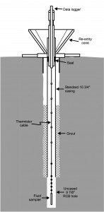 Away from their boundaries, Earth’s tectonic plates are known to move steadily at rates equal to those defined over geologic time scales, i.e. at centimeters per year, but near plate boundaries motions are episodic. Stresses accumulate for years to hundreds of years, and are then released suddenly through large amounts of slip. These events are usually accompanied by earthquakes, which can be damaging when they occur near centers of population. Wherever they occur, earthquakes affect the geologic environment by changing the hydrologic structure of the surrounding crustal rock directly (e.g. fracturing creates new pathways for fluid flow), and indirectly (e.g. squeezing the crust creates pressure gradients which drive fluid flow, and intensive shaking can result in enhanced pressure of pore fluids). These strain induced pressure changes can be observed for hundreds of kilometers from sites of slip. Observations of tectonic activity at the Cascadia subduction zone can be made using Circulation Obviation Retrofit Kit (CORK) instruments. CORKs are installed at boreholes drilled several hundred meters into the ocean crust in order to monitor pressures below the seafloor. The measured amount of pressure change at the borehole site can be used to determine the magnitude of slip and thus the efficiency with which earthquakes are generated…
With the new-found ability to study active plate tectonic processes, seismogenic slip, and related fluid flow using seafloor hydrologic instrumentation, comes new motivation to increase the rate with which information can be gathered. Towards these ends, we have built new CORK data logging units that take advantage of technologies developed since original CORK installations. Improvements include 1) increased sensor resolution that will allow a closer view of the plate-scale processes at work, and 2) compatability with the Neptune fiber-optic cable network that will provide power and allow data to be received in real time on shore. This will eliminate the need for submersible visits for data downloads, and allow measurements to be made on a nearly continuous basis (1 Hz sampling), thus providing observations that will properly link hydrologic, geodynamic, and seismic processes.